
 Mikhaylovka
Dyrestuy
Mikhaylovka
Mayskiy
Novobessergenevka
Tersky District
Lesnoy
Tertezh
Kuz'minskiye Otverzhki
Mikhaylovka
Dyrestuy
Mikhaylovka
Mayskiy
Novobessergenevka
Tersky District
Lesnoy
Tertezh
Kuz'minskiye Otverzhki
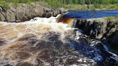
Voitsky Padun on the map, Nadvoitsy, Russian Federation
Photo
Where is located Voitsky Padun
Voitsky Padun — local attraction, which is located at д. Надвоицы, Nadvoitsy, Republic of Karelia, 186431 and belongs to the category — nature preserve. Average visitor rating for this place — 4.8 (according to 214 ratings, information from open sources and relevant for 2022).
Exact location — Voitsky Padun, marked on the map with a red marker.
You can get directions to Voitsky Padun on the map from your location.
What else is interesting in Nadvoitsy? You can see all the sights if you go to the city page.
Coordinates
Voitsky Padun, Russian Federation coordinates in decimal format: latitude — 63.88306406907246, longitude — 34.31064059862696. When converted to degrees, minutes, seconds Voitsky Padun has the following coordinates: 63°52′59.03 north latitude and 34°18′38.31 east longitude.
Nearby cities
The largest cities that are located nearby:
- Petrozavodsk — 233 km
- Severodvinsk — 276 km
- Arkhangelsk — 308 km
- Oulu
 (Finland) — 429 km
 - Saint Petersburg — 489 km
- Kolpino — 503 km
- Cherepovets — 565 km
- Vologda — 607 km
- Tampere (Finland) — 614 km
- Vantaa (Finland) — 643 km
- Helsinki (Finland) — 657 km
- Espoo (Finland) — 667 km
- Rybinsk — 699 km
- Tallinn
 (Estonia) — 727 km
 - Tartu (Estonia) — 750 km
- Turku (Finland) — 757 km
- Pskov — 757 km
- Yaroslavl — 768 km
- Kostroma — 783 km
Distance to the capital
Distance to the capital (Moscow) is about — 922 km.